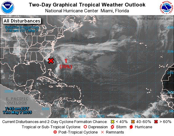
Technically, hurricane season starts on June 1 each year. However, that doesn’t mean tropical storms won’t develop before then, and North Carolina could be affected by one as early as this Friday.
All week long, National Weather Service and National Hurricane Center forecasters have been watching the west Florida panhandle for a low forming off the coast. As of this morning, the National Hurricane Center had given the storm a 70% chance of becoming a tropical cyclone in the next two days.
As of now, however, the disturbance is stalled about 220 miles south-southeast of the South and North Carolina border, with the outer edge of showers clipping the coastal Carolinas. The system is becoming much more organized, with showers and thunderstorms increasing in coverage and intensity.
The storm will continue to organize and strengthen as it sits in the Atlantic, but will make a surge northward towards the Carolinas later in the weekend. Assuming this storm does fulfill its potential, it would become the first sub-tropical/tropical storm of the 2015 Atlantic hurricane season, and would be named “Ana.”
With the large surface area of the system in question, impacts will be seen all over North and South Carolina this weekend. Coastal and mainland threats include heavy rain along with relatively strong wind gusts and dangerous rip currents. Rainfall has already begun in southeast NC and could amount to 3-6 inches when it’s all said and done. Storm surge is not expected to be a threat.
Assuming this does become the first named storm of the year, Ana would be only one of 43 named storms in the month of May since the storm tracking began in the 19th century. Especially this early in May, storms like this are very rare.
“It is rather early in the year for a tropical storm: this system would be one of the earliest subtropical or tropical storms to affect the U.S. on record,” said Weather Channel meteorologist Stu Ostro.
For Raleigh, we could see anywhere from 1-3 inches and locally more rain depending on where the track takes this storm. The weekend looks to be very wet for North Carolina.
“Locally, we’re going to see increased rain chances and possibly some gusty winds, but we’re not going to see what we normally would from a tropical system in terms of heavy rain or flooding,” said WRAL Meteorologist Elizabeth Gardner when discussing the storm yesterday.
Regardless of whether the storm reaches its full potential, a storm this early in the season is a reminder to be ready for anything.
For updated information on the storm, you should monitor local TV and News outlets for updated storm tracks and hazards. Also, you can go to the NWS website and access tons of information on the storm.

Leave a Reply