In the winter of 2014, the “Polar Vortex” brought historic snowfall and near-zero temperatures to North Carolina. Now that sunny skies and 70 degrees have banished polar weather back to the poles, a new noteworthy weather pattern may be on the horizon — one that would make Raleigh weather even more unpredictable than usual.
El Nino, the more historically common of the two global temperature patterns, may be just weeks away from officially beginning. The U.S. Climate Prediction center is forecasting greater than 50% odds it will arrive by this summer and greater than 65% odds it will be in effect by Christmas.
El Nino periods rarely last more than 12 months and occur every three to five years; it’s usually not too unusual of an event. But combined with climate change and the record-setting 2014 winter, 2014-15’s El Nino could be different than ever before.
A New Kind of El Nino
Writes Eric Holthaus of Slate.com, “Peering below the ocean’s surface, water temperatures are already off-the-charts-hot. If that warm water makes it to the surface, the planet could be in line for one of the most intense El Niños ever recorded” — perhaps unsurprising, considering the steady rise in global temperatures over the past 70 years, but dramatic nonetheless. “That would be enough to shift weather patterns worldwide and make the next couple of years among the hottest we’ve ever known.”
Changes would be felt not just on land but at sea, as well.
La Nina events have reduced the pace of sea level rise from 3.5 to 2.4 millimeters per year since 2003 by “shifting water from the oceans to land,” according to Alister Doyle of Reuters.
Yet natural passage of time (water eventually runs back to the ocean) and an El Nino event, which generally shifts weather patterns to the opposite of La Nina, could amplify the increase to record levels.
Local Uncertainty
How would Leesville, Raleigh and North Carolina be affected? That’s not quite as certain, and such uncertainty may worry some.
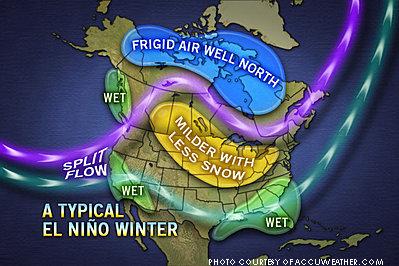
Holthaus writes that El Nino typically makes for wetter, warmer winters in the Southeast U.S. and “snowier-than-average” winters in the mid-Atlantic. Which region the Triangle falls in is determined by the strength of the jet stream and varies from year to year.
Reports WRAL meteorologist Greg Fischel, “El Nino patterns that are in place during the summer and fall tend to suppress tropical cyclone development in the Atlantic basin…[which] can tilt the odds toward drier than normal weather during that time frame. El Nino patterns have stronger correlations…in NC during the colder half of the year, with a tendency toward being cooler than average and having above normal precipitation during El Nino.”
It’s hard to believe that the 2014-15 winter could actually be colder and wetter than 2013-14. The State Dept. of Transportation spent $62 million ($22 million over budget) to prepare for and repair after a series of ice storms this past winter; Raleigh also set two record lows in January alone and broke freezing for just two hours over a three-day stretch in mid-January, the coldest stretch without snow on the ground in area history. Apparently, though, it could be.
Nonetheless, expert opinion remains decidedly inconclusive about the future of weather both locally and globally during this volatile time for climate change. An El Nino event in 2014 could make thermometers and rain gauges even more chaotic.

Leave a Reply